Deep River hiking
- Distance: 3.3 mi
- Elevation gain: 64 m
- Maximum elevation: 149 m
- Elevation loss: 63 m
- Minimum elevation: 129 m
- Moving time: 1 h 12 m
- Moving speed: 2.7 mph
- Maximum speed: 28.2 mph
- Total time: 1 h 19 m
- Global speed: 2.5 mph
Interactive trail map
Trail profile
- Distance: 3.3 mi
- Elevation gain: 64 m
- Maximum elevation: 149 m
- Elevation loss: 63 m
- Minimum elevation: 129 m
- Moving time: 1 h 12 m
- Moving speed: 2.7 mph
- Maximum speed: 28.2 mph
- Total time: 1 h 19 m
- Global speed: 2.5 mph
About this trail
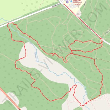
Name: Deep River hiking trail, distance, elevation, map, profile, GPS track
Coordinates: 46.08143 -77.48381 46.09051 -77.47152
Other hiking, mountain biking, running and outdoor activity trails
Click on a trail to view its statistics, map and profile.
Deep River Loop Walk near Kennedy Creek
Canada > Ontario > Renfrew County > Deep River
Distance: 2.0 mi • Elevation gain: 39 m • Maximum elevation: 150 m
Deep River Loop Walk near Ottawa River
Canada > Ontario > Renfrew County > Deep River
Distance: 1.9 mi • Elevation gain: 30 m • Maximum elevation: 135 m
4 Season Trail: C Loop
Canada > Ontario > Renfrew County > Deep River
Distance: 4.0 mi • Elevation gain: 72 m • Maximum elevation: 135 m