Make a donation
Gear up for your next adventure:
As an Amazon Associate, this site earns from qualifying purchases at no extra cost to you.
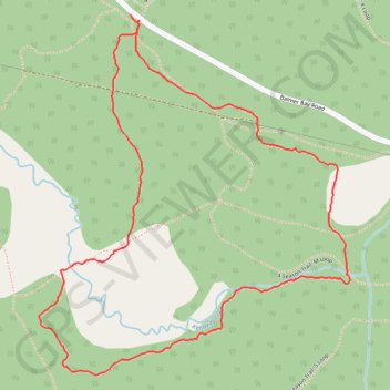
Deep River Loop Walk near Kennedy Creek
- Distance: 2.0 mi
- Elevation gain: 39 m
- Maximum elevation: 150 m
- Elevation loss: 38 m
- Minimum elevation: 129 m
- Moving time: 46 m 26 s
- Moving speed: 2.6 mph
- Maximum speed: 6.7 mph
- Total time: 50 m 2 s
- Global speed: 2.4 mph
Interactive trail map
Make a donation
Gear up for your next adventure:
As an Amazon Associate, this site earns from qualifying purchases at no extra cost to you.
Trail profile
- Distance: 2.0 mi
- Elevation gain: 39 m
- Maximum elevation: 150 m
- Elevation loss: 38 m
- Minimum elevation: 129 m
- Moving time: 46 m 26 s
- Moving speed: 2.6 mph
- Maximum speed: 6.7 mph
- Total time: 50 m 2 s
- Global speed: 2.4 mph
Make a donation
Gear up for your next adventure:
As an Amazon Associate, this site earns from qualifying purchases at no extra cost to you.
About this trail
Name: Deep River Loop Walk near Kennedy Creek trail, distance, elevation, map, profile, GPS track
Coordinates: 46.07900 -77.47496 46.08744 -77.46446
Make a donation
Gear up for your next adventure:
As an Amazon Associate, this site earns from qualifying purchases at no extra cost to you.
Other hiking, mountain biking, running and outdoor activity trails
Click on a trail to view its statistics, map and profile.
Deep River Loop Walk near Ottawa River
Canada > Ontario > Renfrew County > Deep River
Distance: 1.9 mi • Elevation gain: 30 m • Maximum elevation: 135 m
4 Season Trail: C Loop
Canada > Ontario > Renfrew County > Deep River
Distance: 4.0 mi • Elevation gain: 72 m • Maximum elevation: 135 m
Deep River hiking
Canada > Ontario > Renfrew County > Deep River
Distance: 3.3 mi • Elevation gain: 64 m • Maximum elevation: 149 m
Make a donation
Gear up for your next adventure:
As an Amazon Associate, this site earns from qualifying purchases at no extra cost to you.