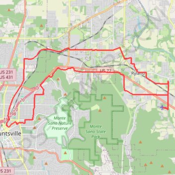
25 mile Bike Ride, Huntsville/Gurley AL
Moontown Airport
- Distance: 25.2 mi
- Elevation gain: 377 m
- Maximum elevation: 307 m
- Elevation loss: 377 m
- Minimum elevation: 190 m
- Moving time: 2 h 18 m
- Moving speed: 10.9 mph
- Maximum speed: 34.3 mph
- Total time: 2 h 58 m
- Global speed: 8.5 mph
Interactive trail map
Trail profile
- Distance: 25.2 mi
- Elevation gain: 377 m
- Maximum elevation: 307 m
- Elevation loss: 377 m
- Minimum elevation: 190 m
- Moving time: 2 h 18 m
- Moving speed: 10.9 mph
- Maximum speed: 34.3 mph
- Total time: 2 h 58 m
- Global speed: 8.5 mph
About this trail
Name: 25 mile Bike Ride, Huntsville/Gurley AL trail, distance, elevation, map, profile, GPS track
Coordinates: 34.73386 -86.58661 34.78642 -86.45652
Other hiking, mountain biking, running and outdoor activity trails
Click on a trail to view its statistics, map and profile.
South Plateau MTB Loop
United States > Alabama > Madison County > Huntsville
Distance: 6.2 mi • Elevation gain: 144 m • Maximum elevation: 503 m
Monte Sano Mountain Loop via Sinks Trail, Stone Cuts Trail and North Plateau Loop
United States > Alabama > Madison County > Huntsville
The Monte Sano Mountain Loop offers an invigorating hike through diverse terrain and striking features. The loop showcases impressive rock formations and limestone cliffs, particularly along the Stone Cuts Trail, where hikers are enveloped by towering stone walls. Along the way, views open up to expansive…
Distance: 2.5 mi • Elevation gain: 157 m • Maximum elevation: 497 m
Arrowhead Trail and Natural Well Trail Loop in Monte Sano State Park
United States > Alabama > Madison County > Huntsville > Mountain Heights
Arrowhead
Distance: 7.6 mi • Elevation gain: 371 m • Maximum elevation: 462 m
Legacy Loop Trail
United States > Alabama > Madison County > Huntsville > Hawks Ridge
Distance: 2.0 mi • Elevation gain: 93 m • Maximum elevation: 330 m
Bankhead Trail and Oak Park Trail MTB Ride in Monte Sano Nature Preserve
United States > Alabama > Madison County > Huntsville > Hawks Ridge
Distance: 2.8 mi • Elevation gain: 42 m • Maximum elevation: 412 m
Toll Gate Greenway MTB in Monte Sano State Park
United States > Alabama > Madison County > Huntsville > Oak Park
Distance: 2.6 mi • Elevation gain: 164 m • Maximum elevation: 445 m
McKay Trail/Monte Sano State Park (MSSP) ride
United States > Alabama > Madison County > Huntsville
Distance: 9.0 mi • Elevation gain: 323 m • Maximum elevation: 502 m
Monte Sano Loop Ride
United States > Alabama > Madison County > Huntsville
Afternoon Mountain Bike Ride
Distance: 8.1 mi • Elevation gain: 284 m • Maximum elevation: 492 m
Warpath Ridge MTB Trail
United States > Alabama > Madison County > Huntsville
Distance: 4.5 mi • Elevation gain: 31 m • Maximum elevation: 499 m
Land Trust Ride
United States > Alabama > Madison County > Huntsville
Distance: 11.8 mi • Elevation gain: 481 m • Maximum elevation: 494 m
Tally-Ho Trail
United States > Alabama > Madison County > Huntsville
Distance: 0.6 mi • Elevation gain: 7 m • Maximum elevation: 489 m