Import a GPX file

Lake Louise

Banff National Park. #Hiking #Running #Banff

  • Distance: 2.9 mi
  • Elevation gain: 37 m
  • Maximum elevation: 1,747 m
  • Elevation loss: 37 m
  • Minimum elevation: 1,735 m

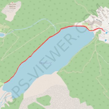
Interactive trail map

Trail profile

  • Distance: 2.9 mi
  • Elevation gain: 37 m
  • Maximum elevation: 1,747 m
  • Elevation loss: 37 m
  • Minimum elevation: 1,735 m

About this trail

Other hiking, mountain biking, running and outdoor activity trails

Click on a trail to view its statistics, map and profile.

Lake Louise - Big Beehive - Plain of Six Glaciers

Canada > Alberta > Improvement District No. 9

Banff National Park. #Hiking #Loop #Banff

Distance: 9.0 mi • Elevation gain: 826 m • Maximum elevation: 2,259 m

Lake Louise - Plain of the Six Glaciers

Canada > Alberta > Improvement District No. 9

Banff National Park. #Hiking #Loop #Banff #Louise #Glaciers

Distance: 13.6 mi • Elevation gain: 1,262 m • Maximum elevation: 2,335 m

Lake Louise - Plain of 6 Glaciers - Lake Agnes

Canada > Alberta > Improvement District No. 9

Banff National Park. #Hiking #Loop #Banff

Distance: 12.0 mi • Elevation gain: 995 m • Maximum elevation: 2,263 m

Banff National Park - Lake Louise

Canada > Alberta > Improvement District No. 9

#Bike #Banff

Distance: 38.4 mi • Elevation gain: 601 m • Maximum elevation: 2,038 m

Lake Louise and Lake Agnes Loop

Canada > Alberta > Improvement District No. 9

Distance: 7.0 mi • Elevation gain: 669 m • Maximum elevation: 2,254 m

Gear up for your next adventure:

🍱Food Containers - Reusable containers for outdoor meals
🖼️Topographic Map Art - Decorative 3D-effect posters of famous UK peaks and regions
🔥Reusable Hand Warmers - Maintain dexterity in your fingers for precise map handling
🗺️Topographic Maps - Detailed maps showing elevation and terrain features
🎒Backpack Rain Covers - Universal waterproof covers to protect your gear from downpours

As an Amazon Associate, this site earns from qualifying purchases at no extra cost to you.