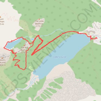
Lake Louise and Lake Agnes Loop
- Distance: 7.0 mi
- Elevation gain: 669 m
- Maximum elevation: 2,254 m
- Elevation loss: 671 m
- Minimum elevation: 1,737 m
- Moving time: 3 h 47 m
- Moving speed: 1.9 mph
- Maximum speed: 3.5 mph
- Total time: 5 h 2 m
- Global speed: 1.4 mph
Interactive trail map
Trail profile
- Distance: 7.0 mi
- Elevation gain: 669 m
- Maximum elevation: 2,254 m
- Elevation loss: 671 m
- Minimum elevation: 1,737 m
- Moving time: 3 h 47 m
- Moving speed: 1.9 mph
- Maximum speed: 3.5 mph
- Total time: 5 h 2 m
- Global speed: 1.4 mph
About this trail
Name: Lake Louise and Lake Agnes Loop trail, distance, elevation, map, profile, GPS track
Start: Paradise Valley Trail, Improvement District No. 9, Alberta, Canada (51.41599 -116.21556)
End: Paradise Valley Trail, Improvement District No. 9, Alberta, Canada (51.41608 -116.21434)
Coordinates: 51.40817 -116.25191 51.41797 -116.21368
Other hiking, mountain biking, running and outdoor activity trails
Click on a trail to view its statistics, map and profile.