Gower National Landscape Day 2
- Distance: 13.8 mi
- Elevation gain: 552 m
- Maximum elevation: 96 m
- Elevation loss: 570 m
- Minimum elevation: -2 m
- Moving time: 7 h 7 m
- Moving speed: 1.9 mph
- Maximum speed: 5.5 mph
- Total time: 9 h 20 m
- Global speed: 1.5 mph
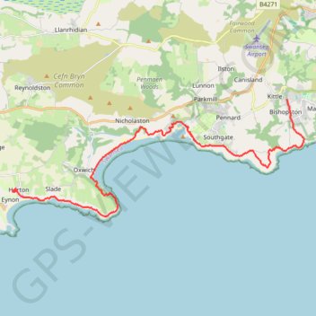
Interactive trail map
Trail profile
- Distance: 13.8 mi
- Elevation gain: 552 m
- Maximum elevation: 96 m
- Elevation loss: 570 m
- Minimum elevation: -2 m
- Moving time: 7 h 7 m
- Moving speed: 1.9 mph
- Maximum speed: 5.5 mph
- Total time: 9 h 20 m
- Global speed: 1.5 mph
About this trail
Name: Gower National Landscape Day 2 trail, distance, elevation, map, profile, GPS track
End: Great House Court, Penrice, Horton, Swansea, Wales, SA3 1LW, United Kingdom (51.55144 -4.20605)
Coordinates: 51.54203 -4.20613 51.58279 -4.04260
Topography: Swansea topographic map, elevation, terrain
Other hiking, mountain biking, running and outdoor activity trails
Click on a trail to view its statistics, map and profile.
Gower National Landscape Day 3
United Kingdom > Wales > Swansea > Horton
Distance: 10.7 mi • Elevation gain: 354 m • Maximum elevation: 85 m