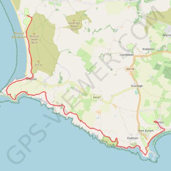
Gower National Landscape Day 3
- Distance: 10.7 mi
- Elevation gain: 354 m
- Maximum elevation: 85 m
- Elevation loss: 400 m
- Minimum elevation: 0 m
- Moving time: 5 h 11 m
- Moving speed: 2.1 mph
- Maximum speed: 12.3 mph
- Total time: 7 h 26 m
- Global speed: 1.4 mph
Interactive trail map
Trail profile
- Distance: 10.7 mi
- Elevation gain: 354 m
- Maximum elevation: 85 m
- Elevation loss: 400 m
- Minimum elevation: 0 m
- Moving time: 5 h 11 m
- Moving speed: 2.1 mph
- Maximum speed: 12.3 mph
- Total time: 7 h 26 m
- Global speed: 1.4 mph
About this trail
Name: Gower National Landscape Day 3 trail, distance, elevation, map, profile, GPS track
Start: Great House Court, Penrice, Horton, Swansea, Wales, SA3 1LW, United Kingdom (51.55146 -4.20598)
Coordinates: 51.53799 -4.30245 51.59473 -4.19894
Topography: Swansea topographic map, elevation, terrain
Other hiking, mountain biking, running and outdoor activity trails
Click on a trail to view its statistics, map and profile.
Gower National Landscape Day 2
United Kingdom > Wales > Swansea > Bishopston
Distance: 13.8 mi • Elevation gain: 552 m • Maximum elevation: 96 m
Gower National Landscape Day 4
United Kingdom > Wales > Swansea > Llangennith
Distance: 11.6 mi • Elevation gain: 254 m • Maximum elevation: 59 m