Thank you for supporting this site ❤️
Make a donation
Make a donation
Gear up for your next adventure:
As an Amazon Associate, this site earns from qualifying purchases at no extra cost to you.
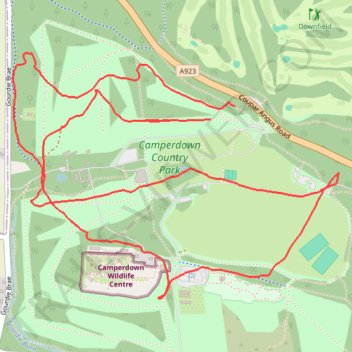
Camperdown Park
- Distance: 3.6 mi
- Elevation gain: 99 m
- Maximum elevation: 156 m
- Elevation loss: 104 m
- Minimum elevation: 90 m
- Moving time: 52 m
- Moving speed: 4.2 mph
- Maximum speed: 9.8 mph
- Total time: 52 m
- Global speed: 4.2 mph
Interactive trail map
Thank you for supporting this site ❤️
Make a donation
Make a donation
Gear up for your next adventure:
As an Amazon Associate, this site earns from qualifying purchases at no extra cost to you.
Trail profile
- Distance: 3.6 mi
- Elevation gain: 99 m
- Maximum elevation: 156 m
- Elevation loss: 104 m
- Minimum elevation: 90 m
- Moving time: 52 m
- Moving speed: 4.2 mph
- Maximum speed: 9.8 mph
- Total time: 52 m
- Global speed: 4.2 mph
Thank you for supporting this site ❤️
Make a donation
Make a donation
Gear up for your next adventure:
As an Amazon Associate, this site earns from qualifying purchases at no extra cost to you.
About this trail
Name: Camperdown Park trail, distance, elevation, map, profile, GPS track
Coordinates: 56.48039 -3.05061 56.48872 -3.03066
Topography: Dundee topographic map, elevation, terrain
Thank you for supporting this site ❤️
Make a donation
Make a donation
Gear up for your next adventure:
As an Amazon Associate, this site earns from qualifying purchases at no extra cost to you.
Other hiking, mountain biking, running and outdoor activity trails
Click on a trail to view its statistics, map and profile.
Camperdown parkrun
United Kingdom > Scotland > Dundee City > Dundee
Distance: 3.1 mi • Elevation gain: 92 m • Maximum elevation: 129 m