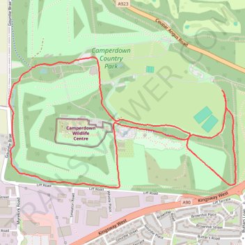
Camperdown parkrun
- Distance: 3.1 mi
- Elevation gain: 92 m
- Maximum elevation: 129 m
- Elevation loss: 94 m
- Minimum elevation: 68 m
- Moving time: 25 m 54 s
- Moving speed: 7.1 mph
- Maximum speed: 10.4 mph
- Total time: 25 m 54 s
- Global speed: 7.1 mph
Interactive trail map
Trail profile
- Distance: 3.1 mi
- Elevation gain: 92 m
- Maximum elevation: 129 m
- Elevation loss: 94 m
- Minimum elevation: 68 m
- Moving time: 25 m 54 s
- Moving speed: 7.1 mph
- Maximum speed: 10.4 mph
- Total time: 25 m 54 s
- Global speed: 7.1 mph
About this trail
Name: Camperdown parkrun trail, distance, elevation, map, profile, GPS track
Coordinates: 56.47823 -3.05093 56.48524 -3.02895
Topography: Dundee topographic map, elevation, terrain
Other hiking, mountain biking, running and outdoor activity trails
Click on a trail to view its statistics, map and profile.
Camperdown Park
United Kingdom > Scotland > Dundee City > Dundee
Distance: 3.6 mi • Elevation gain: 99 m • Maximum elevation: 156 m