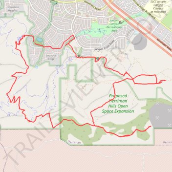
Herriman Hills Open Space
- Distance: 12.1 mi
- Elevation gain: 558 m
- Maximum elevation: 1,850 m
- Elevation loss: 559 m
- Minimum elevation: 1,535 m
- Moving time: 2 h 3 m
- Moving speed: 5.9 mph
- Maximum speed: 25.7 mph
- Total time: 2 h 21 m
- Global speed: 5.1 mph
Interactive trail map
Trail profile
- Distance: 12.1 mi
- Elevation gain: 558 m
- Maximum elevation: 1,850 m
- Elevation loss: 559 m
- Minimum elevation: 1,535 m
- Moving time: 2 h 3 m
- Moving speed: 5.9 mph
- Maximum speed: 25.7 mph
- Total time: 2 h 21 m
- Global speed: 5.1 mph
About this trail
Name: Herriman Hills Open Space trail, distance, elevation, map, profile, GPS track
Coordinates: 40.45854 -112.03059 40.48168 -111.98305
Other hiking, mountain biking, running and outdoor activity trails
Click on a trail to view its statistics, map and profile.
Herriman Hills Open Space
United States > Utah > Salt Lake County > Herriman
Distance: 4.4 mi • Elevation gain: 190 m • Maximum elevation: 1,730 m