Herriman Hills Open Space
- Distance: 4.4 mi
- Elevation gain: 190 m
- Maximum elevation: 1,730 m
- Elevation loss: 188 m
- Minimum elevation: 1,595 m
- Moving time: 1 h 37 m
- Moving speed: 2.7 mph
- Maximum speed: 3.6 mph
- Total time: 1 h 41 m
- Global speed: 2.6 mph
Interactive trail map
Trail profile
- Distance: 4.4 mi
- Elevation gain: 190 m
- Maximum elevation: 1,730 m
- Elevation loss: 188 m
- Minimum elevation: 1,595 m
- Moving time: 1 h 37 m
- Moving speed: 2.7 mph
- Maximum speed: 3.6 mph
- Total time: 1 h 41 m
- Global speed: 2.6 mph
About this trail
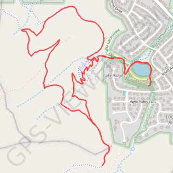
Name: Herriman Hills Open Space trail, distance, elevation, map, profile, GPS track
Coordinates: 40.47301 -112.03306 40.48551 -112.01970
Other hiking, mountain biking, running and outdoor activity trails
Click on a trail to view its statistics, map and profile.
Herriman Hills Open Space
United States > Utah > Salt Lake County > Herriman
Distance: 12.1 mi • Elevation gain: 558 m • Maximum elevation: 1,850 m