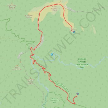
Mount Bogong from Cleve Cole Hut to Ropers Hut in Australian Alps
- Distance: 14.4 mi
- Elevation gain: 1,031 m
- Maximum elevation: 1,984 m
- Elevation loss: 1,097 m
- Minimum elevation: 1,215 m
- Moving time: 6 h 41 m
- Moving speed: 2.2 mph
- Maximum speed: 3.4 mph
- Total time: 8 h 51 m
- Global speed: 1.6 mph
Interactive trail map
Trail profile
- Distance: 14.4 mi
- Elevation gain: 1,031 m
- Maximum elevation: 1,984 m
- Elevation loss: 1,097 m
- Minimum elevation: 1,215 m
- Moving time: 6 h 41 m
- Moving speed: 2.2 mph
- Maximum speed: 3.4 mph
- Total time: 8 h 51 m
- Global speed: 1.6 mph
About this trail
Name: Mount Bogong from Cleve Cole Hut to Ropers Hut in Australian Alps trail, distance, elevation, map, profile, GPS track
Start: Long Spur, Nelse, Shire of East Gippsland, Victoria, Australia (-36.75617 147.32732)
Coordinates: -36.81920 147.27959 -36.73172 147.33197
Other hiking, mountain biking, running and outdoor activity trails
Click on a trail to view its statistics, map and profile.
Ropers Hut to Cleve Cole Hut via Howman Falls in Bogong Natural Area
Distance: 7.8 mi • Elevation gain: 888 m • Maximum elevation: 1,770 m
Rocky Valley Storage to Ropers Hut via Mount Nelse in Australian Alps
Distance: 7.0 mi • Elevation gain: 294 m • Maximum elevation: 1,879 m