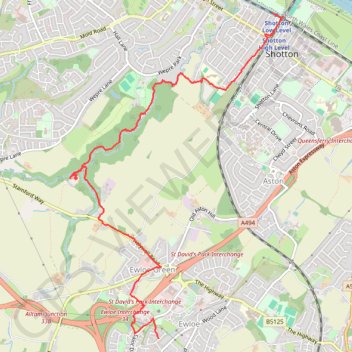
Ewloe Castle - Wepre Brook - Shotton
Morning Walk
- Distance: 4.4 mi
- Elevation gain: 30 m
- Maximum elevation: 89 m
- Elevation loss: 112 m
- Minimum elevation: 5 m
- Moving time: 1 h 47 m
- Moving speed: 2.4 mph
- Maximum speed: 4.4 mph
- Total time: 2 h 47 m
- Global speed: 1.6 mph
Interactive trail map
Trail profile
- Distance: 4.4 mi
- Elevation gain: 30 m
- Maximum elevation: 89 m
- Elevation loss: 112 m
- Minimum elevation: 5 m
- Moving time: 1 h 47 m
- Moving speed: 2.4 mph
- Maximum speed: 4.4 mph
- Total time: 2 h 47 m
- Global speed: 1.6 mph
About this trail
Name: Ewloe Castle - Wepre Brook - Shotton trail, distance, elevation, map, profile, GPS track
Start: 16, Maes Glas, Hawarden, Ewloe, Flintshire, Wales, CH5 3GD, United Kingdom (53.18610 -3.05493)
End: King Edward Street, Shotton, Flintshire, Wales, CH5 1DW, United Kingdom (53.21417 -3.03854)
Coordinates: 53.18610 -3.06769 53.21417 -3.03710
Topography: Flintshire topographic map, elevation, terrain
Other hiking, mountain biking, running and outdoor activity trails
Click on a trail to view its statistics, map and profile.
Kearsley Farm
United Kingdom > Wales > Flintshire > Hawarden
Morning Walk
Distance: 1.3 mi • Elevation gain: 24 m • Maximum elevation: 92 m