Kearsley Farm
Morning Walk
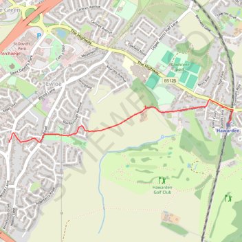
- Distance: 1.3 mi
- Elevation gain: 24 m
- Maximum elevation: 92 m
- Elevation loss: 10 m
- Minimum elevation: 70 m
- Moving time: 25 m 4 s
- Moving speed: 3.0 mph
- Maximum speed: 4.4 mph
- Total time: 26 m 10 s
- Global speed: 2.9 mph
Interactive trail map
Trail profile
- Distance: 1.3 mi
- Elevation gain: 24 m
- Maximum elevation: 92 m
- Elevation loss: 10 m
- Minimum elevation: 70 m
- Moving time: 25 m 4 s
- Moving speed: 3.0 mph
- Maximum speed: 4.4 mph
- Total time: 26 m 10 s
- Global speed: 2.9 mph
About this trail
Name: Kearsley Farm trail, distance, elevation, map, profile, GPS track
Start: Hawarden, Woodlands Court, Hawarden, Flintshire, Wales, CH5 3NB, United Kingdom (53.18490 -3.03203)
End: Wood Lane, Hawarden, Ewloe, Flintshire, Wales, CH5 3LY, United Kingdom (53.18372 -3.05519)
Coordinates: 53.18372 -3.05519 53.18643 -3.03154
Topography: Flintshire topographic map, elevation, terrain
Other hiking, mountain biking, running and outdoor activity trails
Click on a trail to view its statistics, map and profile.
Ewloe Castle - Wepre Brook - Shotton
United Kingdom > Wales > Flintshire > Ewloe
Morning Walk
Distance: 4.4 mi • Elevation gain: 30 m • Maximum elevation: 89 m