Import a GPX file

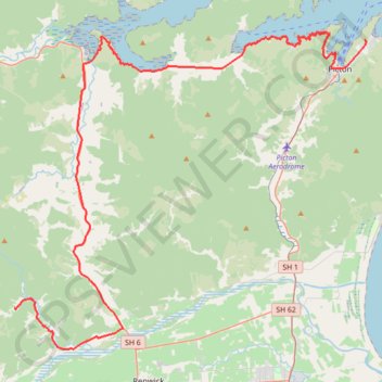
Picton - Onamalutu Campsite

Kaituna River, Wairau River, Ōhinemahuta River. #Bike #Road #Sea #Mountain #River #Nature

  • Distance: 45.2 mi
  • Elevation gain: 1,465 m
  • Maximum elevation: 155 m
  • Elevation loss: 1,378 m
  • Minimum elevation: 1 m

Interactive trail map

Trail profile

  • Distance: 45.2 mi
  • Elevation gain: 1,465 m
  • Maximum elevation: 155 m
  • Elevation loss: 1,378 m
  • Minimum elevation: 1 m

About this trail

Other hiking, mountain biking, running and outdoor activity trails

Click on a trail to view its statistics, map and profile.

Onamalutu Campsite - Saint Arnaud

New Zealand > Marlborough > Marlborough District

Wairau River, Lake Rotoiti #Bike #River #Forest #Mountain #Lake #Nature

Distance: 60.7 mi • Elevation gain: 1,481 m • Maximum elevation: 738 m

Havelock - Nelson

New Zealand > Marlborough > Marlborough District > Havelock

#Bike #MTB #Mountain #River #Lake #Sea #Forest #Nature

Distance: 38.5 mi • Elevation gain: 1,648 m • Maximum elevation: 744 m

Takorika Summit loop - Havelock

New Zealand > Marlborough > Marlborough District > Havelock

Distance: 6.2 mi • Elevation gain: 758 m • Maximum elevation: 704 m

Gear up for your next adventure:

🛰️Handheld GPS Devices - Reliable GPS units for hiking and outdoor navigation
🩹Hiking First Aid Kits - Compact medical kits tailored for trail injuries and emergencies
📸Action Camera Chest Mounts - Record your ascent following topographic paths hands-free
🧥Softshell Jackets - Breathable jackets for active outdoor use
🕶️Glacier Goggles - Maximum protection for high-altitude snow topography

As an Amazon Associate, this site earns from qualifying purchases at no extra cost to you.