Import a GPX file

Onamalutu Campsite - Saint Arnaud

Wairau River, Lake Rotoiti #Bike #River #Forest #Mountain #Lake #Nature

  • Distance: 60.7 mi
  • Elevation gain: 1,481 m
  • Maximum elevation: 738 m
  • Elevation loss: 951 m
  • Minimum elevation: 65 m

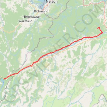
Interactive trail map

Trail profile

  • Distance: 60.7 mi
  • Elevation gain: 1,481 m
  • Maximum elevation: 738 m
  • Elevation loss: 951 m
  • Minimum elevation: 65 m

About this trail

Name: Onamalutu Campsite - Saint Arnaud trail, distance, elevation, map, profile, GPS track

Start: Onamalutu Campsite, Onamalutu Road, Marlborough District, Marlborough, New Zealand (-41.45818 173.70421)

End: Kerr Bay Campsite, Lake Road, Saint Arnaud, 7053, New Zealand (-41.80589 172.84746)

Coordinates: -41.80589 172.84746 -41.45127 173.75408

Other hiking, mountain biking, running and outdoor activity trails

Click on a trail to view its statistics, map and profile.

Tour Te Waipounamu

New Zealand > Tasman > Tasman District > Port Pūponga

Bikepacking race through the South Island of New Zealand. #Bike #Race #Island #Sea #Pacific #Ocean #Nature #Mountain #Forest #Countryside

Distance: 820.8 mi • Elevation gain: 23,362 m • Maximum elevation: 1,946 m

Picton - Onamalutu Campsite

New Zealand > Marlborough > Marlborough District > Waikawa

Kaituna River, Wairau River, Ōhinemahuta River. #Bike #Road #Sea #Mountain #River #Nature

Distance: 45.2 mi • Elevation gain: 1,465 m • Maximum elevation: 155 m

Gear up for your next adventure:

🔋Power Banks - Portable chargers for long outdoor trips
🧣Fleece Neck Warmers - Extra insulation for winter topographic surveys
🚲Bikepacking Frame Bags - Storage for tools and navigation gear on long off-road rides
🍲Portable Camping Stoves - Fast-boiling stoves for hot meals on remote topographic survey trips
🎒Hiking Daypacks - Compact backpacks ideal for short hikes and excursions

As an Amazon Associate, this site earns from qualifying purchases at no extra cost to you.