Import a GPX file

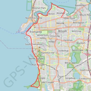
Attadale - Woodman Point

#Bike #Loop #Perth

  • Distance: 24.8 mi
  • Elevation gain: 275 m
  • Maximum elevation: 22 m
  • Elevation loss: 290 m
  • Minimum elevation: -1 m

Interactive trail map

Trail profile

  • Distance: 24.8 mi
  • Elevation gain: 275 m
  • Maximum elevation: 22 m
  • Elevation loss: 290 m
  • Minimum elevation: -1 m

About this trail

Other hiking, mountain biking, running and outdoor activity trails

Click on a trail to view its statistics, map and profile.

Perth - Swan River - Cottelsoe Beach

Australia > Western Australia > Town of Victoria Park

#Bike #Loop #Perth

Distance: 33.7 mi • Elevation gain: 376 m • Maximum elevation: 43 m

Perth along the coast

Australia > Western Australia > City of Perth

#Bike #Loop #Perth

Distance: 90.4 mi • Elevation gain: 1,208 m • Maximum elevation: 61 m

MAnning Park

Australia > Western Australia

Distance: 7.4 mi • Elevation gain: 181 m • Maximum elevation: 46 m

Gear up for your next adventure:

🪢Paracord - Multi-purpose cord for camping and survival
📻Hand-Crank Emergency Radios - Stay updated on weather warnings in remote areas
🎒Hiking Backpacks - Comfortable backpacks for day hikes and multi-day treks
🔋Rechargeable Batteries - Eco-friendly power for headlamps and older GPS units
🧴Tick Removal Tools - Small, essential health tool for UK woodland and moorland

As an Amazon Associate, this site earns from qualifying purchases at no extra cost to you.