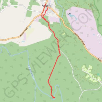
Import a GPX file

Appin Falls

#Hiking

  • Distance: 8.8 mi
  • Elevation gain: 154 m
  • Maximum elevation: 296 m
  • Elevation loss: 149 m
  • Minimum elevation: 235 m

Interactive trail map

Trail profile

  • Distance: 8.8 mi
  • Elevation gain: 154 m
  • Maximum elevation: 296 m
  • Elevation loss: 149 m
  • Minimum elevation: 235 m

About this trail

Other hiking, mountain biking, running and outdoor activity trails

Click on a trail to view its statistics, map and profile.

Appin - Minerva pool - Wedderburn

Australia > New South Wales > Appin

Georges river. Dharawal National Park. #Hiking #MTB #Dharawal

Distance: 7.2 mi • Elevation gain: 220 m • Maximum elevation: 281 m

Gear up for your next adventure:

🔋Rechargeable Batteries - Eco-friendly power for headlamps and older GPS units
🧷Tenacious Repair Tape - Instant fix for torn tents, jackets, or dry bags
📸Action Camera Chest Mounts - Record your ascent following topographic paths hands-free
🔋Solar Power Banks - Keep your GPS and phone charged during multi-day expeditions
🧭Emergency Beacons - Safety beacons for remote outdoor locations

As an Amazon Associate, this site earns from qualifying purchases at no extra cost to you.