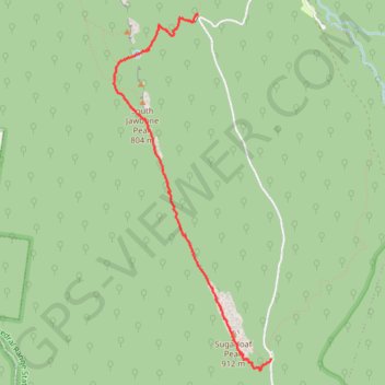
Sugarloaf Peak - South Jawbone Peak
Interactive trail map
Trail profile
- Distance: 3.3 mi
- Elevation gain: 177 m
- Maximum elevation: 920 m
- Elevation loss: 490 m
- Minimum elevation: 456 m
- Moving time: 2 h 4 m
- Moving speed: 1.6 mph
- Maximum speed: 6.7 mph
- Total time: 3 h 5 m
- Global speed: 1.1 mph
About this trail
Name: Sugarloaf Peak - South Jawbone Peak trail, distance, elevation, map, profile, GPS track
Start: Cerberus Road, Taggerty, Shire of Murrindindi, Victoria, 3714, Australia (-37.41014 145.75747)
Coordinates: -37.41113 145.74100 -37.38147 145.75747
Other hiking, mountain biking, running and outdoor activity trails
Click on a trail to view its statistics, map and profile.
Tallarook - Eildon - Hurstbridge
Australia > Victoria > Tallarook
#Bike
Distance: 173.2 mi • Elevation gain: 4,897 m • Maximum elevation: 868 m
Cathedral Ranges and Neds Peak loop hike
Distance: 9.0 mi • Elevation gain: 721 m • Maximum elevation: 825 m
Cathedral Range State Park
Australia > Victoria > Rubicon
Distance: 10.5 mi • Elevation gain: 780 m • Maximum elevation: 920 m
The cathedral and the jawbones
Distance: 7.8 mi • Elevation gain: 632 m • Maximum elevation: 817 m