Make a donation
Gear up for your next adventure:
As an Amazon Associate, this site earns from qualifying purchases at no extra cost to you.
The cathedral and the jawbones
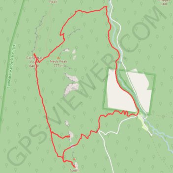
- Distance: 7.8 mi
- Elevation gain: 632 m
- Maximum elevation: 817 m
- Elevation loss: 632 m
- Minimum elevation: 308 m
Interactive trail map
Make a donation
Gear up for your next adventure:
As an Amazon Associate, this site earns from qualifying purchases at no extra cost to you.
Trail profile
- Distance: 7.8 mi
- Elevation gain: 632 m
- Maximum elevation: 817 m
- Elevation loss: 632 m
- Minimum elevation: 308 m
Make a donation
Gear up for your next adventure:
As an Amazon Associate, this site earns from qualifying purchases at no extra cost to you.
About this trail
Name: The cathedral and the jawbones trail, distance, elevation, map, profile, GPS track
Start: Little River Road, Taggerty, Shire of Murrindindi, Victoria, 3714, Australia (-37.37863 145.75946)
End: Little River Road, Taggerty, Shire of Murrindindi, Victoria, 3714, Australia (-37.37852 145.75948)
Coordinates: -37.38874 145.73396 -37.35735 145.75969
Make a donation
Gear up for your next adventure:
As an Amazon Associate, this site earns from qualifying purchases at no extra cost to you.
Other hiking, mountain biking, running and outdoor activity trails
Click on a trail to view its statistics, map and profile.
Tallarook - Eildon - Hurstbridge
Australia > Victoria > Tallarook
#Bike
Distance: 173.2 mi • Elevation gain: 4,897 m • Maximum elevation: 868 m
Cathedral Ranges and Neds Peak loop hike
Distance: 9.0 mi • Elevation gain: 721 m • Maximum elevation: 825 m
Make a donation
Gear up for your next adventure:
As an Amazon Associate, this site earns from qualifying purchases at no extra cost to you.
Cathedral Range State Park
Australia > Victoria > Rubicon
Distance: 10.5 mi • Elevation gain: 780 m • Maximum elevation: 920 m
Cathedral Range - Neds Peak
Distance: 3.4 mi • Elevation gain: 447 m • Maximum elevation: 747 m