Make a donation
Gear up for your next adventure:
As an Amazon Associate, this site earns from qualifying purchases at no extra cost to you.
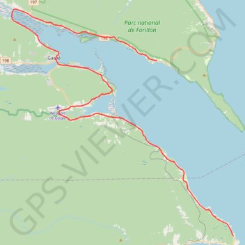
Gaspé - Saint-Georges-de-Malbaie
Forillon National Park. Gulf of Saint Lawrence. #Bike #Gaspé #SaintGeorgesDeMalbaie #Forillon #SaintLawrence #Atlantic
- Distance: 47.1 mi
- Elevation gain: 796 m
- Maximum elevation: 80 m
- Elevation loss: 785 m
- Minimum elevation: -1 m
Interactive trail map
Make a donation
Gear up for your next adventure:
As an Amazon Associate, this site earns from qualifying purchases at no extra cost to you.
Trail profile
- Distance: 47.1 mi
- Elevation gain: 796 m
- Maximum elevation: 80 m
- Elevation loss: 785 m
- Minimum elevation: -1 m
Make a donation
Gear up for your next adventure:
As an Amazon Associate, this site earns from qualifying purchases at no extra cost to you.
About this trail
Name: Gaspé - Saint-Georges-de-Malbaie trail, distance, elevation, map, profile, GPS track
Coordinates: 48.63159 -64.55554 48.88586 -64.17878
Make a donation
Gear up for your next adventure:
As an Amazon Associate, this site earns from qualifying purchases at no extra cost to you.
Other hiking, mountain biking, running and outdoor activity trails
Click on a trail to view its statistics, map and profile.
Madeleine - Gaspé
Canada > Quebec > La Haute-Gaspésie > Sainte-Madeleine-de-la-Rivière-Madeleine > Madeleine-Centre
Gulf of Saint Lawrence. #Bike #Madeleine #Gaspé #SaintLawrence #Atlantic
Distance: 74.6 mi • Elevation gain: 2,303 m • Maximum elevation: 294 m
Saint-Georges-de-Malbaie - Saint-François-de-Pabos
Canada > Quebec > Le Rocher-Percé > Percé > Saint-Georges-de-Malbaie > Pointe-Saint-Pierre
Gulf of Saint Lawrence. #Bike #SaintLawrence #Atlantic
Distance: 42.7 mi • Elevation gain: 700 m • Maximum elevation: 142 m