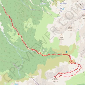
Pointe du Sifflet depuis Prabert (Belledonne)
- Distance: 10.8 mi
- Elevation gain: 1,292 m
- Maximum elevation: 2,290 m
- Elevation loss: 1,315 m
- Minimum elevation: 1,073 m
Interactive trail map
Trail profile
- Distance: 10.8 mi
- Elevation gain: 1,292 m
- Maximum elevation: 2,290 m
- Elevation loss: 1,315 m
- Minimum elevation: 1,073 m
About this trail
Name: Pointe du Sifflet depuis Prabert (Belledonne) trail, distance, elevation, map, profile, GPS track
Coordinates: 45.21152 5.97882 45.24479 6.03107
Other hiking, mountain biking, running and outdoor activity trails
Click on a trail to view its statistics, map and profile.
PT23DS2 Lörrach → Cadaqués
Germany > Baden-Württemberg > Landkreis Lörrach > Lörrach (Kernstadt)
Distance: 652.9 mi • Elevation gain: 13,130 m • Maximum elevation: 1,505 m
Chemin de Saint-Jacques-de-Compostelle
Switzerland > Geneva > Geneva
Distance: 694.6 mi • Elevation gain: 25,262 m • Maximum elevation: 1,430 m
Trail de l’Étendard - 44km
France > Auvergne-Rhône-Alpes > Isère > Le Bourg-d'Oisans > Le Bassey
Distance: 28.0 mi • Elevation gain: 3,160 m • Maximum elevation: 2,726 m