Mount Ngungun
Glass House Mountains National Park. #Hiking #GlassHouse
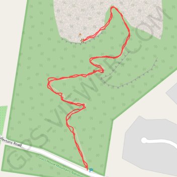
- Distance: 1.5 mi
- Elevation gain: 167 m
- Maximum elevation: 212 m
- Elevation loss: 168 m
- Minimum elevation: 51 m
- Moving time: 47 m 49 s
- Moving speed: 1.9 mph
- Maximum speed: 4.6 mph
- Total time: 51 m 55 s
- Global speed: 1.7 mph
Interactive trail map
Trail profile
- Distance: 1.5 mi
- Elevation gain: 167 m
- Maximum elevation: 212 m
- Elevation loss: 168 m
- Minimum elevation: 51 m
- Moving time: 47 m 49 s
- Moving speed: 1.9 mph
- Maximum speed: 4.6 mph
- Total time: 51 m 55 s
- Global speed: 1.7 mph
About this trail
Name: Mount Ngungun trail, distance, elevation, map, profile, GPS track
Coordinates: -26.90364 152.93389 -26.89871 152.93666
Other hiking, mountain biking, running and outdoor activity trails
Click on a trail to view its statistics, map and profile.