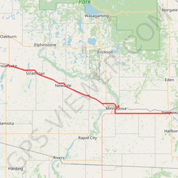
Shoal Lake - Neepawa
Interactive trail map
Trail profile
- Distance: 60.0 mi
- Elevation gain: 203 m
- Maximum elevation: 609 m
- Elevation loss: 404 m
- Minimum elevation: 352 m
About this trail
Name: Shoal Lake - Neepawa trail, distance, elevation, map, profile, GPS track
End: Neepawa, Manitoba, R0J 1H0, Canada (50.22916 -99.45491)
Coordinates: 50.22578 -100.59346 50.44177 -99.45479
Other hiking, mountain biking, running and outdoor activity trails
Click on a trail to view its statistics, map and profile.
Neepawa - Portage la Prairie
#Bike #Neepawa #PortageLaPrairie
Distance: 62.7 mi • Elevation gain: 77 m • Maximum elevation: 355 m
Squirrel Hills
Canada > Rural Municipality of Minto - Odanah
Evening MTB Ride
Distance: 9.6 mi • Elevation gain: 279 m • Maximum elevation: 586 m
Squirrel Hills
Canada > Rural Municipality of Minto - Odanah
Evening Ride
Distance: 10.1 mi • Elevation gain: 303 m • Maximum elevation: 586 m