Squirrel Hills
Evening Ride
- Distance: 10.1 mi
- Elevation gain: 303 m
- Maximum elevation: 586 m
- Elevation loss: 302 m
- Minimum elevation: 511 m
- Moving time: 1 h 18 m
- Moving speed: 7.7 mph
- Maximum speed: 20.5 mph
- Total time: 1 h 42 m
- Global speed: 5.9 mph
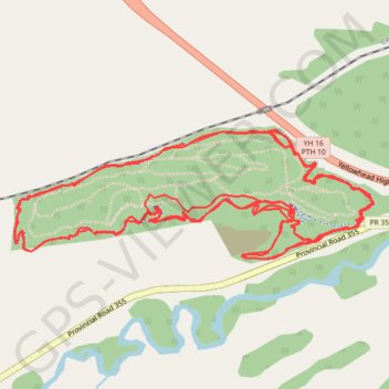
Interactive trail map
Trail profile
- Distance: 10.1 mi
- Elevation gain: 303 m
- Maximum elevation: 586 m
- Elevation loss: 302 m
- Minimum elevation: 511 m
- Moving time: 1 h 18 m
- Moving speed: 7.7 mph
- Maximum speed: 20.5 mph
- Total time: 1 h 42 m
- Global speed: 5.9 mph
About this trail
Name: Squirrel Hills trail, distance, elevation, map, profile, GPS track
Start: Perimiter Trail, Rural Municipality of Minto - Odanah, Manitoba, Canada (50.25557 -99.88704)
End: Perimiter Trail, Rural Municipality of Minto - Odanah, Manitoba, Canada (50.25553 -99.88716)
Coordinates: 50.25409 -99.90716 50.25894 -99.88613
Other hiking, mountain biking, running and outdoor activity trails
Click on a trail to view its statistics, map and profile.
Squirrel Hills
Canada > Rural Municipality of Minto - Odanah
Evening MTB Ride
Distance: 9.6 mi • Elevation gain: 279 m • Maximum elevation: 586 m