Make a donation
Gear up for your next adventure:
As an Amazon Associate, this site earns from qualifying purchases at no extra cost to you.
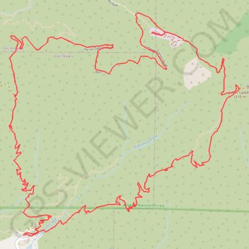
Mount Lukens
Loop hike to Mount Lukens from Deukmejian Wilderness Park in Angeles National Forest. #Hiking #Loop #Mountain #Nature #Forest #Angeles
- Distance: 9.9 mi
- Elevation gain: 1,065 m
- Maximum elevation: 1,537 m
- Elevation loss: 1,064 m
- Minimum elevation: 715 m
- Moving time: 1 h 34 m
- Moving speed: 6.3 mph
- Maximum speed: 8.1 mph
- Total time: 1 h 34 m
- Global speed: 6.3 mph
Interactive trail map
Make a donation
Gear up for your next adventure:
As an Amazon Associate, this site earns from qualifying purchases at no extra cost to you.
Trail profile
- Distance: 9.9 mi
- Elevation gain: 1,065 m
- Maximum elevation: 1,537 m
- Elevation loss: 1,064 m
- Minimum elevation: 715 m
- Moving time: 1 h 34 m
- Moving speed: 6.3 mph
- Maximum speed: 8.1 mph
- Total time: 1 h 34 m
- Global speed: 6.3 mph
Make a donation
Gear up for your next adventure:
As an Amazon Associate, this site earns from qualifying purchases at no extra cost to you.
About this trail
Name: Mount Lukens trail, distance, elevation, map, profile, GPS track
Coordinates: 34.24964 -118.25543 34.27084 -118.22890
Make a donation
Gear up for your next adventure:
As an Amazon Associate, this site earns from qualifying purchases at no extra cost to you.
Other hiking, mountain biking, running and outdoor activity trails
Click on a trail to view its statistics, map and profile.
Mount Lukens
United States > California > Los Angeles County
Final upper stone canyon trail upper switchbacks restoration
Distance: 9.0 mi • Elevation gain: 520 m • Maximum elevation: 1,537 m