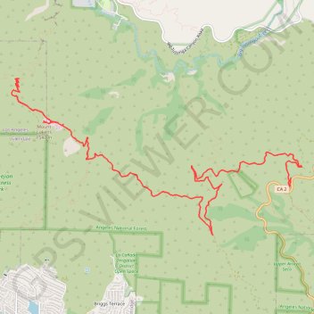
Mount Lukens
Final upper stone canyon trail upper switchbacks restoration
- Distance: 9.0 mi
- Elevation gain: 520 m
- Maximum elevation: 1,537 m
- Elevation loss: 1,132 m
- Minimum elevation: 918 m
- Moving time: 1 h 14 m
- Moving speed: 7.3 mph
- Maximum speed: 17.1 mph
- Total time: 11 h 3 m
- Global speed: 0.8 mph
Interactive trail map
Trail profile
- Distance: 9.0 mi
- Elevation gain: 520 m
- Maximum elevation: 1,537 m
- Elevation loss: 1,132 m
- Minimum elevation: 918 m
- Moving time: 1 h 14 m
- Moving speed: 7.3 mph
- Maximum speed: 17.1 mph
- Total time: 11 h 3 m
- Global speed: 0.8 mph
About this trail
Name: Mount Lukens trail, distance, elevation, map, profile, GPS track
Start: Mount Lukens Road, Los Angeles County, California, 91214, United States (34.26842 -118.23552)
End: Hoyt Mtn Road, Los Angeles County, California, United States (34.26025 -118.19265)
Coordinates: 34.25140 -118.24498 34.27567 -118.19053
Other hiking, mountain biking, running and outdoor activity trails
Click on a trail to view its statistics, map and profile.
Mount Lukens Loop from Deukmejian Wilderness Park
United States > California > Los Angeles County > Glendale
Starting at Mount Lukens Trailhead in Deukmejian Wilderness Park, the route first leaves the Stone Barn area, crosses Dunsmore Creek on the lower park connector, and joins Crescenta View Trail before climbing through chaparral and sage scrub above Dunsmore Canyon toward The Redoubt. The ascent continues over…
Distance: 9.9 mi • Elevation gain: 1,065 m • Maximum elevation: 1,537 m