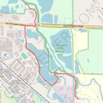
Poudre River Trail
- Distance: 1.8 mi
- Elevation gain: 9 m
- Maximum elevation: 1,497 m
- Elevation loss: 2 m
- Minimum elevation: 1,489 m
- Moving time: 42 m 46 s
- Moving speed: 2.6 mph
- Maximum speed: 4.4 mph
- Total time: 53 m 39 s
- Global speed: 2.1 mph
Interactive trail map
Trail profile
- Distance: 1.8 mi
- Elevation gain: 9 m
- Maximum elevation: 1,497 m
- Elevation loss: 2 m
- Minimum elevation: 1,489 m
- Moving time: 42 m 46 s
- Moving speed: 2.6 mph
- Maximum speed: 4.4 mph
- Total time: 53 m 39 s
- Global speed: 2.1 mph
About this trail
Name: Poudre River Trail trail, distance, elevation, map, profile, GPS track
Coordinates: 40.55589 -105.02972 40.57024 -105.01913
Other hiking, mountain biking, running and outdoor activity trails
Click on a trail to view its statistics, map and profile.
Poudre River trail
United States > Colorado > Larimer County > Fort Collins
Fort Collins Cycling
Distance: 29.0 mi • Elevation gain: 189 m • Maximum elevation: 1,557 m