Poudre River trail
Fort Collins Cycling
- Distance: 29.0 mi
- Elevation gain: 189 m
- Maximum elevation: 1,557 m
- Elevation loss: 136 m
- Minimum elevation: 1,470 m
- Moving time: 3 h 4 m
- Moving speed: 9.5 mph
- Maximum speed: 23.4 mph
- Total time: 4 h 27 m
- Global speed: 6.5 mph
Interactive trail map
Trail profile
- Distance: 29.0 mi
- Elevation gain: 189 m
- Maximum elevation: 1,557 m
- Elevation loss: 136 m
- Minimum elevation: 1,470 m
- Moving time: 3 h 4 m
- Moving speed: 9.5 mph
- Maximum speed: 23.4 mph
- Total time: 4 h 27 m
- Global speed: 6.5 mph
About this trail
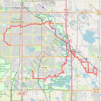
Name: Poudre River trail trail, distance, elevation, map, profile, GPS track
Coordinates: 40.49237 -105.10826 40.57019 -104.94794
Other hiking, mountain biking, running and outdoor activity trails
Click on a trail to view its statistics, map and profile.
Devils Backbone up to Horsetooth Mountain and back
United States > Colorado > Larimer County > Loveland
Distance: 34.7 mi • Elevation gain: 685 m • Maximum elevation: 1,746 m
Poudre River Trail
United States > Colorado > Larimer County > Fort Collins
Distance: 1.8 mi • Elevation gain: 9 m • Maximum elevation: 1,497 m