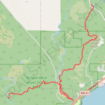
USA MN SHT - South Cross River Campsite to Britton Peak Trailhead
- Distance: 7.8 mi
- Elevation gain: 391 m
- Maximum elevation: 439 m
- Elevation loss: 359 m
- Minimum elevation: 204 m
- Moving time: 4 h 24 m
- Moving speed: 1.8 mph
- Maximum speed: 3.5 mph
- Total time: 5 h 14 m
- Global speed: 1.5 mph
Interactive trail map
Trail profile
- Distance: 7.8 mi
- Elevation gain: 391 m
- Maximum elevation: 439 m
- Elevation loss: 359 m
- Minimum elevation: 204 m
- Moving time: 4 h 24 m
- Moving speed: 1.8 mph
- Maximum speed: 3.5 mph
- Total time: 5 h 14 m
- Global speed: 1.5 mph
About this trail
Name: USA MN SHT - South Cross River Campsite to Britton Peak Trailhead trail, distance, elevation, map, profile, GPS track
Coordinates: 47.55624 -90.91617 47.59889 -90.85803
Other hiking, mountain biking, running and outdoor activity trails
Click on a trail to view its statistics, map and profile.
USA MN SHT - Crystal Creek Campsite to South Cross River Campsite
United States > Minnesota > Cook County > Schroeder Township
Distance: 12.4 mi • Elevation gain: 355 m • Maximum elevation: 432 m
USA, MN, Carlton Peak and Tofte Peak, Temperance River State Park
United States > Minnesota > Cook County
Cook County Hiking
Distance: 1.6 mi • Elevation gain: 123 m • Maximum elevation: 448 m