Fletchers Creek Ecological Preserve Loop
Fletchers Creek Ecological Preserve. #Hiking #Running #Loop #FletchersCreek
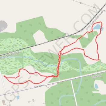
- Distance: 2.9 mi
- Elevation gain: 19 m
- Maximum elevation: 296 m
- Elevation loss: 19 m
- Minimum elevation: 286 m
Interactive trail map
Trail profile
- Distance: 2.9 mi
- Elevation gain: 19 m
- Maximum elevation: 296 m
- Elevation loss: 19 m
- Minimum elevation: 286 m
About this trail
Name: Fletchers Creek Ecological Preserve Loop trail, distance, elevation, map, profile, GPS track
Start: Concession Road 7, Puslinch, Wellington County, Ontario, N0B 2J0, Canada (43.41368 -80.12024)
End: Concession Road 7, Puslinch, Wellington County, Ontario, N0B 2J0, Canada (43.41368 -80.12024)
Coordinates: 43.41265 -80.12035 43.42070 -80.10282
Other hiking, mountain biking, running and outdoor activity trails
Click on a trail to view its statistics, map and profile.
Aldershot - Kitchener
Canada > Ontario > Halton Region > Burlington
#Bike
Distance: 49.1 mi • Elevation gain: 570 m • Maximum elevation: 346 m