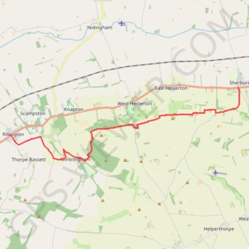
Rillington - Sherburn
Via The Wolds Way #Hiking
- Distance: 9.7 mi
- Elevation gain: 235 m
- Maximum elevation: 181 m
- Elevation loss: 228 m
- Minimum elevation: 34 m
Interactive trail map
Trail profile
- Distance: 9.7 mi
- Elevation gain: 235 m
- Maximum elevation: 181 m
- Elevation loss: 228 m
- Minimum elevation: 34 m
About this trail
Name: Rillington - Sherburn trail, distance, elevation, map, profile, GPS track
Coordinates: 54.14697 -0.69611 54.17762 -0.53203
Topography: North Yorkshire topographic map, elevation, terrain
Other hiking, mountain biking, running and outdoor activity trails
Click on a trail to view its statistics, map and profile.
Settrington Beacon Loop from Norton-on-Derwent
United Kingdom > England > North Yorkshire > Norton-on-Derwent
Distance: 18.6 mi • Elevation gain: 412 m • Maximum elevation: 201 m
Thorpe Basset Loop
United Kingdom > England > North Yorkshire > Thorpe Bassett
Distance: 8.0 mi • Elevation gain: 309 m • Maximum elevation: 201 m