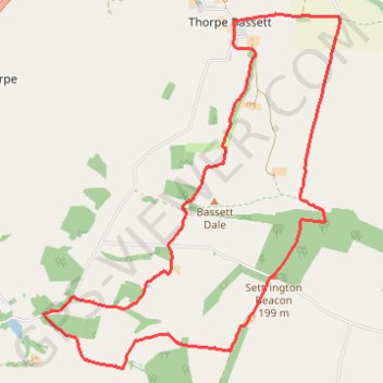
Thorpe Basset Loop
- Distance: 8.0 mi
- Elevation gain: 309 m
- Maximum elevation: 201 m
- Elevation loss: 309 m
- Minimum elevation: 44 m
- Moving time: 2 h 6 m
- Moving speed: 3.8 mph
- Maximum speed: 7.2 mph
- Total time: 2 h 9 m
- Global speed: 3.7 mph
Interactive trail map
Trail profile
About this trail
Name: Thorpe Basset Loop trail, distance, elevation, map, profile, GPS track
Coordinates: 54.11507 -0.71243 54.14848 -0.66464
Topography: North Yorkshire topographic map, elevation, terrain
Other hiking, mountain biking, running and outdoor activity trails
Click on a trail to view its statistics, map and profile.
Rillington - Sherburn
United Kingdom > England > North Yorkshire > Rillington
Via The Wolds Way #Hiking
Distance: 9.7 mi • Elevation gain: 235 m • Maximum elevation: 181 m