Make a donation
Gear up for your next adventure:
As an Amazon Associate, this site earns from qualifying purchases at no extra cost to you.
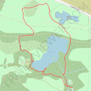
Loop Walk at Mugdock Country Park
- Distance: 1.6 mi
- Elevation gain: 35 m
- Maximum elevation: 172 m
- Elevation loss: 36 m
- Minimum elevation: 149 m
- Moving time: 1 h 2 m
- Moving speed: 1.6 mph
- Maximum speed: 5.2 mph
- Total time: 1 h 7 m
- Global speed: 1.5 mph
Interactive trail map
Make a donation
Gear up for your next adventure:
As an Amazon Associate, this site earns from qualifying purchases at no extra cost to you.
Trail profile
- Distance: 1.6 mi
- Elevation gain: 35 m
- Maximum elevation: 172 m
- Elevation loss: 36 m
- Minimum elevation: 149 m
- Moving time: 1 h 2 m
- Moving speed: 1.6 mph
- Maximum speed: 5.2 mph
- Total time: 1 h 7 m
- Global speed: 1.5 mph
Make a donation
Gear up for your next adventure:
As an Amazon Associate, this site earns from qualifying purchases at no extra cost to you.
About this trail
Name: Loop Walk at Mugdock Country Park trail, distance, elevation, map, profile, GPS track
Start: Mugdock, Stirling, Scotland, G62 8BF, United Kingdom (55.96338 -4.31712)
Coordinates: 55.96333 -4.32522 55.97046 -4.31710
Topography: Stirling topographic map, elevation, terrain
Make a donation
Gear up for your next adventure:
As an Amazon Associate, this site earns from qualifying purchases at no extra cost to you.
Other hiking, mountain biking, running and outdoor activity trails
Click on a trail to view its statistics, map and profile.
West Highland Way between Milngavie and Craigallian Loch
United Kingdom > Scotland > East Dunbartonshire > Milngavie
Distance: 4.6 mi • Elevation gain: 83 m • Maximum elevation: 117 m
Trails in and around Mugdock Country Park
United Kingdom > Scotland > Stirling > Mugdock
Distance: 2.3 mi • Elevation gain: 85 m • Maximum elevation: 163 m
Loop Trail in and around Mugdock Country Park
United Kingdom > Scotland > East Dunbartonshire > Milngavie
Distance: 2.4 mi • Elevation gain: 91 m • Maximum elevation: 163 m
Make a donation
Gear up for your next adventure:
As an Amazon Associate, this site earns from qualifying purchases at no extra cost to you.
West Highland Way: Milngavie to Mugdock Park
United Kingdom > Scotland > East Dunbartonshire > Glasgow
Distance: 4.3 mi • Elevation gain: 72 m • Maximum elevation: 115 m
Loop walk in Mugdock County Park
United Kingdom > Scotland > Stirling > Mugdock
Distance: 2.9 mi • Elevation gain: 44 m • Maximum elevation: 179 m