Pelgrimsweg van Vezelay deel 1 Z Vezelay - Nevers - Gargilesse
Vezelay - Nevers - Gargilesse: 314 km<br><br><a href="https://www.santiago.nl/werkgroepen/werkgroep-pelgrimsweg-vezelay/">Website</a>
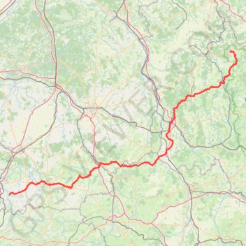
- Distance: 185.6 mi
- Elevation gain: 3,384 m
- Maximum elevation: 345 m
- Elevation loss: 3,517 m
- Minimum elevation: 147 m
Interactive trail map
Trail profile
- Distance: 185.6 mi
- Elevation gain: 3,384 m
- Maximum elevation: 345 m
- Elevation loss: 3,517 m
- Minimum elevation: 147 m
About this trail
Name: Pelgrimsweg van Vezelay deel 1 Z Vezelay - Nevers - Gargilesse trail, distance, elevation, map, profile, GPS track
Coordinates: 46.51373 1.59775 47.46575 3.80453
Other hiking, mountain biking, running and outdoor activity trails
Click on a trail to view its statistics, map and profile.
La Loire à Vélo
France > Pays de la Loire > Loire-Atlantique > Saint-Brevin-les-Pins
Distance: 408.8 mi • Elevation gain: 2,492 m • Maximum elevation: 186 m
PT23DS2 Lörrach → Cadaqués
Germany > Baden-Württemberg > Landkreis Lörrach > Lörrach (Kernstadt)
Distance: 652.9 mi • Elevation gain: 13,130 m • Maximum elevation: 1,505 m
GR 654 - Le chemin vers Saint-Jacques-de-Compostelle via Vézelay
France > Nouvelle-Aquitaine > Dordogne > Bergerac
Distance: 503.8 mi • Elevation gain: 9,631 m • Maximum elevation: 670 m