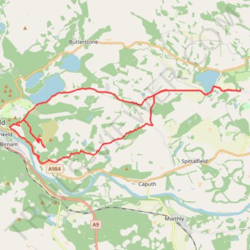
Around Newtyle Hill, Dunkeld, Perthshire
- Distance: 17.5 mi
- Elevation gain: 599 m
- Maximum elevation: 278 m
- Elevation loss: 600 m
- Minimum elevation: 51 m
- Moving time: 2 h 10 m
- Moving speed: 8.0 mph
- Maximum speed: 26.7 mph
- Total time: 3 h 11 m
- Global speed: 5.5 mph
Interactive trail map
Trail profile
- Distance: 17.5 mi
- Elevation gain: 599 m
- Maximum elevation: 278 m
- Elevation loss: 600 m
- Minimum elevation: 51 m
- Moving time: 2 h 10 m
- Moving speed: 8.0 mph
- Maximum speed: 26.7 mph
- Total time: 3 h 11 m
- Global speed: 5.5 mph
About this trail
Name: Around Newtyle Hill, Dunkeld, Perthshire trail, distance, elevation, map, profile, GPS track
Coordinates: 56.55041 -3.57453 56.57855 -3.42218
Topography: Perth and Kinross topographic map, elevation, terrain
Other hiking, mountain biking, running and outdoor activity trails
Click on a trail to view its statistics, map and profile.
The Knockie, Marlee Loch and Loch of Clunie Loop
United Kingdom > Scotland > Perth and Kinross > Craigie
Loop MTB / run / hike around Blairgowrie via The Knockie, Marlee Loch and Loch of Clunie. #Hiking #Loop #Nature #Countryside #Lake
Distance: 10.7 mi • Elevation gain: 271 m • Maximum elevation: 203 m
Loop Gravel Ride around Blairgowrie and Rattray between Loch of Clunie and Alyth
United Kingdom > Scotland > Perth and Kinross > Newlands
Distance: 24.7 mi • Elevation gain: 529 m • Maximum elevation: 281 m
Inchtuthil Roman Legionary Fortress
United Kingdom > Scotland > Perth and Kinross > Newlands
Inchtuthil Redoubt
Distance: 8.7 mi • Elevation gain: 130 m • Maximum elevation: 97 m
EMTB Gravel: Murthly - Birnam - Loop
United Kingdom > Scotland > Perth and Kinross > Newlands
Around Dunkeld, Perthshire Scotland
Distance: 28.8 mi • Elevation gain: 869 m • Maximum elevation: 305 m
Cally Loch Mountain Bike Ride, Dunkeld
United Kingdom > Scotland > Perth and Kinross
Distance: 24.1 mi • Elevation gain: 605 m • Maximum elevation: 189 m
Mountain Bike loop ride around Murthly, Perthshire Scotland
United Kingdom > Scotland > Perth and Kinross > Murthly > Gellyburn
UK, Perthshire, Dunkeld, Murthly
Distance: 11.2 mi • Elevation gain: 298 m • Maximum elevation: 178 m
Black Hill Roman Watch Tower - Around Meikleour, Perthshire
United Kingdom > Scotland > Perth and Kinross > Newlands
Distance: 12.1 mi • Elevation gain: 246 m • Maximum elevation: 138 m
Mountain Bike Ride Around Clunie, Perthshire
United Kingdom > Scotland > Perth and Kinross
UK, Perthshire, Clunie
Distance: 10.4 mi • Elevation gain: 313 m • Maximum elevation: 210 m
Ninewells Kerb Cairn & Easter Cult Stones
United Kingdom > Scotland > Perth and Kinross
Around Clunie, Perthshire
Distance: 9.6 mi • Elevation gain: 281 m • Maximum elevation: 205 m
Discovering Newtyle Hill tracks by bicycle
United Kingdom > Scotland > Perth and Kinross > Dunkeld
Distance: 6.4 mi • Elevation gain: 330 m • Maximum elevation: 281 m
Ninewells Kerb Cairn
United Kingdom > Scotland > Perth and Kinross
Distance: 7.2 mi • Elevation gain: 166 m • Maximum elevation: 143 m
Kinclaven Wood - Stanley - Bankfoot Loop
United Kingdom > Scotland > Perth and Kinross > Newlands
Distance: 26.7 mi • Elevation gain: 547 m • Maximum elevation: 137 m
Mountain Bike Ride Above Clunie
United Kingdom > Scotland > Perth and Kinross > Craigie
#UK #Perthshire #Clunie
Distance: 5.8 mi • Elevation gain: 189 m • Maximum elevation: 189 m
Around Blairgowrie, Scotland
United Kingdom > Scotland > Perth and Kinross > Craigie
UK, Perthshire, Blairgowrie
Distance: 12.2 mi • Elevation gain: 174 m • Maximum elevation: 81 m
Around Clunie, Perthshire
United Kingdom > Scotland > Perth and Kinross
Afternoon Workout. UK, Perthshire, Blairgowrie
Distance: 10.2 mi • Elevation gain: 309 m • Maximum elevation: 187 m
Around Newtyle Hill near Dunkeld
United Kingdom > Scotland > Perth and Kinross > Clunie
Distance: 15.2 mi • Elevation gain: 594 m • Maximum elevation: 278 m
Around Clunie, Perthshire
United Kingdom > Scotland > Perth and Kinross > Clunie
UK, Perthshire, Blairgowrie
Distance: 4.6 mi • Elevation gain: 152 m • Maximum elevation: 188 m
Mountain Bike Ride Above Clunie
United Kingdom > Scotland > Perth and Kinross
Distance: 9.4 mi • Elevation gain: 278 m • Maximum elevation: 205 m
Around Spittalfield, Scotland
United Kingdom > Scotland > Perth and Kinross
Distance: 11.9 mi • Elevation gain: 278 m • Maximum elevation: 137 m
North of Loch of Clunie
United Kingdom > Scotland > Perth and Kinross > Clunie
UK, Perthshire, Clunie
Distance: 7.6 mi • Elevation gain: 260 m • Maximum elevation: 189 m
Around Loch Ordie
United Kingdom > Scotland > Perth and Kinross
Mountain Bike Ride, UK, Perthshire, Dunkeld
Distance: 22.3 mi • Elevation gain: 579 m • Maximum elevation: 300 m
King's Myre Loop
United Kingdom > Scotland > Perth and Kinross > Newlands
Distance: 24.7 mi • Elevation gain: 365 m • Maximum elevation: 106 m