Make a donation
Gear up for your next adventure:
As an Amazon Associate, this site earns from qualifying purchases at no extra cost to you.
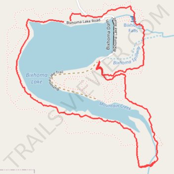
Bixhoma Lake Trail
- Distance: 3.7 mi
- Elevation gain: 160 m
- Maximum elevation: 255 m
- Elevation loss: 158 m
- Minimum elevation: 197 m
- Moving time: 54 m 40 s
- Moving speed: 4.0 mph
- Maximum speed: 14.0 mph
- Total time: 56 m 41 s
- Global speed: 3.9 mph
Interactive trail map
Make a donation
Gear up for your next adventure:
As an Amazon Associate, this site earns from qualifying purchases at no extra cost to you.
Trail profile
- Distance: 3.7 mi
- Elevation gain: 160 m
- Maximum elevation: 255 m
- Elevation loss: 158 m
- Minimum elevation: 197 m
- Moving time: 54 m 40 s
- Moving speed: 4.0 mph
- Maximum speed: 14.0 mph
- Total time: 56 m 41 s
- Global speed: 3.9 mph
Make a donation
Gear up for your next adventure:
As an Amazon Associate, this site earns from qualifying purchases at no extra cost to you.
About this trail
Name: Bixhoma Lake Trail trail, distance, elevation, map, profile, GPS track
Start: Bixhoma Lake Road, Bixby, Wagoner County, Oklahoma, 74043, United States (35.89632 -95.79850)
End: Bixhoma Lake Road, Bixby, Wagoner County, Oklahoma, 74043, United States (35.89638 -95.79785)
Coordinates: 35.88533 -95.80292 35.89749 -95.78974
Make a donation
Gear up for your next adventure:
As an Amazon Associate, this site earns from qualifying purchases at no extra cost to you.
Other hiking, mountain biking, running and outdoor activity trails
Click on a trail to view its statistics, map and profile.
Bixhoma Lake Loop Trail
United States > Oklahoma > Wagoner County > Bixby
Distance: 4.3 mi • Elevation gain: 189 m • Maximum elevation: 255 m