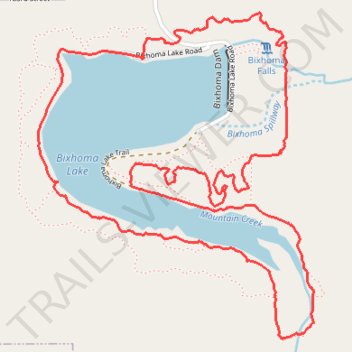
Bixhoma Lake Loop Trail
- Distance: 4.3 mi
- Elevation gain: 189 m
- Maximum elevation: 255 m
- Elevation loss: 189 m
- Minimum elevation: 197 m
- Moving time: 1 h 12 m
- Moving speed: 3.6 mph
- Maximum speed: 6.8 mph
- Total time: 1 h 17 m
- Global speed: 3.3 mph
Interactive trail map
Trail profile
- Distance: 4.3 mi
- Elevation gain: 189 m
- Maximum elevation: 255 m
- Elevation loss: 189 m
- Minimum elevation: 197 m
- Moving time: 1 h 12 m
- Moving speed: 3.6 mph
- Maximum speed: 6.8 mph
- Total time: 1 h 17 m
- Global speed: 3.3 mph
About this trail
Name: Bixhoma Lake Loop Trail trail, distance, elevation, map, profile, GPS track
Start: Bixhoma Lake Road, Bixby, Wagoner County, Oklahoma, 74043, United States (35.89615 -95.79788)
End: Bixhoma Lake Road, Bixby, Wagoner County, Oklahoma, 74043, United States (35.89613 -95.79790)
Coordinates: 35.88535 -95.80287 35.89790 -95.78978
Other hiking, mountain biking, running and outdoor activity trails
Click on a trail to view its statistics, map and profile.
Bixhoma Lake Trail
United States > Oklahoma > Wagoner County > Bixby
Distance: 3.7 mi • Elevation gain: 160 m • Maximum elevation: 255 m