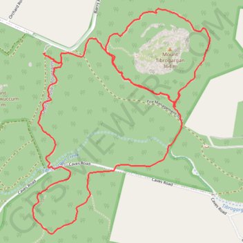
Mount Tibberoowuccum - Mount Tribrogargan - Trachyte Circuit
Glass House Mountains National Park. #Hiking #Loop #GlassHouse
- Distance: 5.7 mi
- Elevation gain: 241 m
- Maximum elevation: 89 m
- Elevation loss: 241 m
- Minimum elevation: 22 m
- Moving time: 1 h 39 m
- Moving speed: 3.5 mph
- Maximum speed: 6.6 mph
- Total time: 1 h 46 m
- Global speed: 3.2 mph
Interactive trail map
Trail profile
- Distance: 5.7 mi
- Elevation gain: 241 m
- Maximum elevation: 89 m
- Elevation loss: 241 m
- Minimum elevation: 22 m
- Moving time: 1 h 39 m
- Moving speed: 3.5 mph
- Maximum speed: 6.6 mph
- Total time: 1 h 46 m
- Global speed: 3.2 mph
About this trail
Name: Mount Tibberoowuccum - Mount Tribrogargan - Trachyte Circuit trail, distance, elevation, map, profile, GPS track
Coordinates: -26.94097 152.93561 -26.92377 152.95081
Other hiking, mountain biking, running and outdoor activity trails
Click on a trail to view its statistics, map and profile.