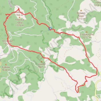
Željin-Rogačka čuka
- Distance: 11.5 mi
- Elevation gain: 886 m
- Maximum elevation: 1,769 m
- Elevation loss: 887 m
- Minimum elevation: 1,042 m
- Moving time: 5 h 1 m
- Moving speed: 2.3 mph
- Maximum speed: 5.7 mph
- Total time: 6 h 56 m
- Global speed: 1.7 mph
Interactive trail map
Trail profile
- Distance: 11.5 mi
- Elevation gain: 886 m
- Maximum elevation: 1,769 m
- Elevation loss: 887 m
- Minimum elevation: 1,042 m
- Moving time: 5 h 1 m
- Moving speed: 2.3 mph
- Maximum speed: 5.7 mph
- Total time: 6 h 56 m
- Global speed: 1.7 mph
About this trail
Name: Željin-Rogačka čuka trail, distance, elevation, map, profile, GPS track
Coordinates: 43.43553 20.79476 43.47870 20.86060
Other hiking, mountain biking, running and outdoor activity trails
Click on a trail to view its statistics, map and profile.
2022_Yu
Slovenia > Ajdovščina > Žapuže
Distance: 1,526.9 mi • Elevation gain: 32,048 m • Maximum elevation: 1,950 m
Trasa
Serbia > Central Serbia > Rasina Administrative District > Aleksandrovac Municipality > Ploca
Distance: 7.9 mi • Elevation gain: 834 m • Maximum elevation: 1,769 m
Mitrovo polje_Zeljin_Rogavcina
Serbia > Central Serbia > Rasina Administrative District > Aleksandrovac Municipality > Bzenice > Митрово Поље
Distance: 12.7 mi • Elevation gain: 1,236 m • Maximum elevation: 1,769 m