Import a GPX file

Auckland Domain

#Hiking #Loop

  • Distance: 1.9 mi
  • Elevation gain: 52 m
  • Maximum elevation: 84 m
  • Elevation loss: 52 m
  • Minimum elevation: 64 m

Interactive trail map

Trail profile

  • Distance: 1.9 mi
  • Elevation gain: 52 m
  • Maximum elevation: 84 m
  • Elevation loss: 52 m
  • Minimum elevation: 64 m

About this trail

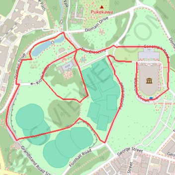
Name: Auckland Domain trail, distance, elevation, map, profile, GPS track

Start: Parnell, Auckland, Waitematā, Auckland, 1052, New Zealand (-36.86009 174.77727)

End: Museum Circuit, Parnell, Auckland, Waitematā, Auckland, 1052, New Zealand (-36.86008 174.77703)

Coordinates: -36.86305 174.77131 -36.85900 174.77872

Other hiking, mountain biking, running and outdoor activity trails

Click on a trail to view its statistics, map and profile.

Mount Hobson - Mount Saint John - Mount Eden

New Zealand > Auckland > Auckland

Auckland. #Hiking #Loop

Distance: 12.8 mi • Elevation gain: 522 m • Maximum elevation: 182 m

Auckland Domain

New Zealand > Auckland > Auckland

#Hiking #Loop

Distance: 2.8 mi • Elevation gain: 145 m • Maximum elevation: 74 m

Gear up for your next adventure:

🥤Hydration Bladders - Hands-free hydration systems for backpacks
🧰Survival Kits - Emergency tools for remote environments
🛑Emergency Bivvy Bags - Heat-reflective survival bags for unexpected nights out
🔦LED Camping Lanterns - Illumination for reading maps inside your tent at night
🦯Walking Poles - Supportive poles for long-distance walking

As an Amazon Associate, this site earns from qualifying purchases at no extra cost to you.