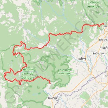
2023DI160
- Distance: 110.8 mi
- Elevation gain: 9,545 m
- Maximum elevation: 2,143 m
- Elevation loss: 9,511 m
- Minimum elevation: 299 m
Interactive trail map
Trail profile
- Distance: 110.8 mi
- Elevation gain: 9,545 m
- Maximum elevation: 2,143 m
- Elevation loss: 9,511 m
- Minimum elevation: 299 m
About this trail
Name: 2023DI160 trail, distance, elevation, map, profile, GPS track
Start: Ban Mae Hoi, Ban Luang, Chiang Mai Province, 50160, Thailand (18.48681 98.66748)
Coordinates: 18.48106 98.44566 18.75977 98.92339
Other hiking, mountain biking, running and outdoor activity trails
Click on a trail to view its statistics, map and profile.
17 - Chiang Mai - Trek Jour 2
Distance: 4.7 mi • Elevation gain: 222 m • Maximum elevation: 1,409 m