Make a donation
Gear up for your next adventure:
As an Amazon Associate, this site earns from qualifying purchases at no extra cost to you.
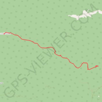
17 - Chiang Mai - Trek Jour 2
- Distance: 4.7 mi
- Elevation gain: 222 m
- Maximum elevation: 1,409 m
- Elevation loss: 545 m
- Minimum elevation: 1,077 m
Interactive trail map
Make a donation
Gear up for your next adventure:
As an Amazon Associate, this site earns from qualifying purchases at no extra cost to you.
Trail profile
- Distance: 4.7 mi
- Elevation gain: 222 m
- Maximum elevation: 1,409 m
- Elevation loss: 545 m
- Minimum elevation: 1,077 m
Make a donation
Gear up for your next adventure:
As an Amazon Associate, this site earns from qualifying purchases at no extra cost to you.
About this trail
Name: 17 - Chiang Mai - Trek Jour 2 trail, distance, elevation, map, profile, GPS track
Start: Hot District, Chiang Mai Province, 50240, Thailand (18.68467 98.47443)
End: Ban Mae Chon Noi, Chiang Mai Province, Thailand (18.69952 98.42882)
Coordinates: 18.68296 98.42852 18.70012 98.47450
Make a donation
Gear up for your next adventure:
As an Amazon Associate, this site earns from qualifying purchases at no extra cost to you.
Other hiking, mountain biking, running and outdoor activity trails
Click on a trail to view its statistics, map and profile.
2023DI160
Distance: 110.8 mi • Elevation gain: 9,545 m • Maximum elevation: 2,143 m