Make a donation
Gear up for your next adventure:
As an Amazon Associate, this site earns from qualifying purchases at no extra cost to you.
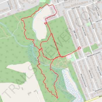
Petawawa woodland trails
- Distance: 2.3 mi
- Elevation gain: 26 m
- Maximum elevation: 156 m
- Elevation loss: 26 m
- Minimum elevation: 143 m
- Moving time: 51 m 52 s
- Moving speed: 2.7 mph
- Maximum speed: 12.5 mph
- Total time: 54 m 55 s
- Global speed: 2.6 mph
Interactive trail map
Make a donation
Gear up for your next adventure:
As an Amazon Associate, this site earns from qualifying purchases at no extra cost to you.
Trail profile
- Distance: 2.3 mi
- Elevation gain: 26 m
- Maximum elevation: 156 m
- Elevation loss: 26 m
- Minimum elevation: 143 m
- Moving time: 51 m 52 s
- Moving speed: 2.7 mph
- Maximum speed: 12.5 mph
- Total time: 54 m 55 s
- Global speed: 2.6 mph
Make a donation
Gear up for your next adventure:
As an Amazon Associate, this site earns from qualifying purchases at no extra cost to you.
About this trail
Name: Petawawa woodland trails trail, distance, elevation, map, profile, GPS track
Coordinates: 45.88615 -77.29078 45.89419 -77.28349
Make a donation
Gear up for your next adventure:
As an Amazon Associate, this site earns from qualifying purchases at no extra cost to you.
Other hiking, mountain biking, running and outdoor activity trails
Click on a trail to view its statistics, map and profile.
Woodland Park
Canada > Ontario > Renfrew County > Petawawa
Distance: 0.7 mi • Elevation gain: 13 m • Maximum elevation: 156 m
Woodland Park
Canada > Ontario > Renfrew County > Petawawa
Distance: 0.7 mi • Elevation gain: 10 m • Maximum elevation: 157 m