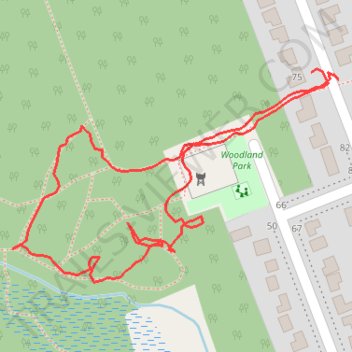
Woodland Park
- Distance: 0.7 mi
- Elevation gain: 10 m
- Maximum elevation: 157 m
- Elevation loss: 12 m
- Minimum elevation: 146 m
- Moving time: 15 m 48 s
- Moving speed: 2.5 mph
- Maximum speed: 5.4 mph
- Total time: 17 m 9 s
- Global speed: 2.3 mph
Interactive trail map
Trail profile
- Distance: 0.7 mi
- Elevation gain: 10 m
- Maximum elevation: 157 m
- Elevation loss: 12 m
- Minimum elevation: 146 m
- Moving time: 15 m 48 s
- Moving speed: 2.5 mph
- Maximum speed: 5.4 mph
- Total time: 17 m 9 s
- Global speed: 2.3 mph
About this trail
Name: Woodland Park trail, distance, elevation, map, profile, GPS track
Coordinates: 45.88879 -77.28713 45.89050 -77.28339
Other hiking, mountain biking, running and outdoor activity trails
Click on a trail to view its statistics, map and profile.
Petawawa woodland trails
Canada > Ontario > Renfrew County > Petawawa
Distance: 2.3 mi • Elevation gain: 26 m • Maximum elevation: 156 m
Woodland Park
Canada > Ontario > Renfrew County > Petawawa
Distance: 0.7 mi • Elevation gain: 13 m • Maximum elevation: 156 m