Thank you for supporting this site ❤️
Make a donation
Make a donation
Gear up for your next adventure:
As an Amazon Associate, this site earns from qualifying purchases at no extra cost to you.
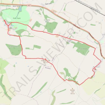
Firle Beacon Loop
- Distance: 7.3 mi
- Elevation gain: 248 m
- Maximum elevation: 217 m
- Elevation loss: 250 m
- Minimum elevation: 24 m
- Moving time: 2 h 33 m
- Moving speed: 2.9 mph
- Maximum speed: 4.5 mph
- Total time: 3 h 3 m
- Global speed: 2.4 mph
Interactive trail map
Thank you for supporting this site ❤️
Make a donation
Make a donation
Gear up for your next adventure:
As an Amazon Associate, this site earns from qualifying purchases at no extra cost to you.
Trail profile
- Distance: 7.3 mi
- Elevation gain: 248 m
- Maximum elevation: 217 m
- Elevation loss: 250 m
- Minimum elevation: 24 m
- Moving time: 2 h 33 m
- Moving speed: 2.9 mph
- Maximum speed: 4.5 mph
- Total time: 3 h 3 m
- Global speed: 2.4 mph
Thank you for supporting this site ❤️
Make a donation
Make a donation
Gear up for your next adventure:
As an Amazon Associate, this site earns from qualifying purchases at no extra cost to you.
About this trail
Name: Firle Beacon Loop trail, distance, elevation, map, profile, GPS track
Coordinates: 50.82437 0.08443 50.84792 0.14028
Topography: East Sussex topographic map, elevation, terrain
Thank you for supporting this site ❤️
Make a donation
Make a donation
Gear up for your next adventure:
As an Amazon Associate, this site earns from qualifying purchases at no extra cost to you.
Other hiking, mountain biking, running and outdoor activity trails
Click on a trail to view its statistics, map and profile.