Make a donation
Gear up for your next adventure:
As an Amazon Associate, this site earns from qualifying purchases at no extra cost to you.
Mount Caburn
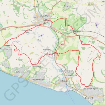
Interactive trail map
Make a donation
Gear up for your next adventure:
As an Amazon Associate, this site earns from qualifying purchases at no extra cost to you.
Trail profile
- Distance: 31.1 mi
- Elevation gain: 961 m
- Maximum elevation: 195 m
- Elevation loss: 960 m
- Minimum elevation: 3 m
Make a donation
Gear up for your next adventure:
As an Amazon Associate, this site earns from qualifying purchases at no extra cost to you.
About this trail
Name: Mount Caburn trail, distance, elevation, map, profile, GPS track
Coordinates: 50.78694 -0.07460 50.87651 0.12733
Topography: East Sussex topographic map, elevation, terrain
Make a donation
Gear up for your next adventure:
As an Amazon Associate, this site earns from qualifying purchases at no extra cost to you.
Other hiking, mountain biking, running and outdoor activity trails
Click on a trail to view its statistics, map and profile.
Firle Beacon Loop
United Kingdom > England > East Sussex > Lewes > Firle > Wick Street
Distance: 7.3 mi • Elevation gain: 248 m • Maximum elevation: 217 m
Bullock Hill trig point
United Kingdom > England > Brighton and Hove > Brighton
Distance: 3.4 mi • Elevation gain: 79 m • Maximum elevation: 196 m