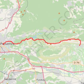
De Puyloubier à Aix en Provence
- Distance: 15.0 mi
- Elevation gain: 1,057 m
- Maximum elevation: 1,011 m
- Elevation loss: 1,202 m
- Minimum elevation: 202 m
Interactive trail map
Trail profile
- Distance: 15.0 mi
- Elevation gain: 1,057 m
- Maximum elevation: 1,011 m
- Elevation loss: 1,202 m
- Minimum elevation: 202 m
About this trail
Name: De Puyloubier à Aix en Provence trail, distance, elevation, map, profile, GPS track
Coordinates: 43.52545 5.45112 43.54167 5.67689
Other hiking, mountain biking, running and outdoor activity trails
Click on a trail to view its statistics, map and profile.
1 LUCENA - MONTPELLIER
Distance: 1,842.0 mi • Elevation gain: 29,500 m • Maximum elevation: 1,048 m
PT23DS2 Lörrach → Cadaqués
Germany > Baden-Württemberg > Landkreis Lörrach > Lörrach (Kernstadt)
Distance: 652.9 mi • Elevation gain: 13,130 m • Maximum elevation: 1,505 m
Chemin de Saint-Jacques-de-Compostelle
Switzerland > Geneva > Geneva
Distance: 694.6 mi • Elevation gain: 25,262 m • Maximum elevation: 1,430 m