T3_Blankenb-Oostend
<p>Uit wandelgids 'Treinstapper 3'</p>
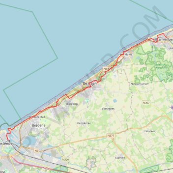
<p><strong>GR 5A Kustroute</strong></p>
<p>Een dagje 'uitwaaien aan zee'. Je wandelt een groot deel op de GR 5A en geniet van een voortdurende afwisseling: zee, strand, duinen, duinpaden en -bossen. Ontdek de 'aubette de la douane' of wat Einstein naar De Haan dreef. Op het einde wacht je de veerboot naar Oostende waar je kunt afsluiten met een hapje en een drankje.</p>
<p>Wens je de afstand aan te passen, geen nood: de Kusttram is nooit veraf.</p>
- Distance: 14.6 mi
- Elevation gain: 167 m
- Maximum elevation: 16 m
- Elevation loss: 169 m
- Minimum elevation: -1 m
Interactive trail map
Trail profile
- Distance: 14.6 mi
- Elevation gain: 167 m
- Maximum elevation: 16 m
- Elevation loss: 169 m
- Minimum elevation: -1 m
About this trail
Name: T3_Blankenb-Oostend trail, distance, elevation, map, profile, GPS track
End: Natiënkaai, Hazegras, Ostend, West Flanders, Flanders, 8400, Belgium (51.22891 2.92483)
Coordinates: 51.22891 2.92256 51.31622 3.13249
Other hiking, mountain biking, running and outdoor activity trails
Click on a trail to view its statistics, map and profile.
De Haan - Duinbossen
Belgium > West Flanders > Ostend > Vlissegem
Distance: 4.1 mi • Elevation gain: 31 m • Maximum elevation: 12 m
Kronkelend bospad in De Haan – Strandpromenade De Haan rondtocht vanuit Concessiewijk
Belgium > West Flanders > Ostend > De Haan > Klemskerke
Distance: 4.1 mi • Elevation gain: 21 m • Maximum elevation: 10 m
Toerke_de_haan_5k
Belgium > West Flanders > Ostend > De Haan > Klemskerke
name=toerke_de_haan_5k
Distance: 3.2 mi • Elevation gain: 31 m • Maximum elevation: 12 m
Duinbossen_dehaan
Belgium > West Flanders > Ostend > De Haan > Klemskerke
Distance: 6.9 mi • Elevation gain: 62 m • Maximum elevation: 12 m
Centerparc 7k
Belgium > West Flanders > Ostend > Nieuwmunster
name=centerparc 7k
Distance: 4.3 mi • Elevation gain: 37 m • Maximum elevation: 12 m