Rydal Adventure Lab
- Distance: 1.7 mi
- Elevation gain: 70 m
- Maximum elevation: 94 m
- Elevation loss: 61 m
- Minimum elevation: 58 m
- Moving time: 32 m 58 s
- Moving speed: 3.0 mph
- Maximum speed: 27.9 mph
- Total time: 46 m 24 s
- Global speed: 2.1 mph
Interactive trail map
Trail profile
- Distance: 1.7 mi
- Elevation gain: 70 m
- Maximum elevation: 94 m
- Elevation loss: 61 m
- Minimum elevation: 58 m
- Moving time: 32 m 58 s
- Moving speed: 3.0 mph
- Maximum speed: 27.9 mph
- Total time: 46 m 24 s
- Global speed: 2.1 mph
About this trail
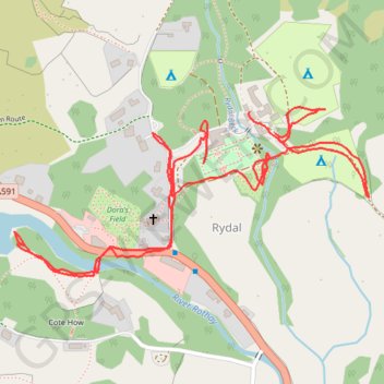
Name: Rydal Adventure Lab trail, distance, elevation, map, profile, GPS track
Coordinates: 54.44643 -2.98557 54.44915 -2.97577
Topography: Westmorland and Furness topographic map, elevation, terrain
Other hiking, mountain biking, running and outdoor activity trails
Click on a trail to view its statistics, map and profile.
Loughrigg Fell loop from Ambleside
United Kingdom > England > Westmorland and Furness > Ambleside
Distance: 7.9 mi • Elevation gain: 489 m • Maximum elevation: 329 m
Rydal Cave, Grasmere and Rydal Water Loop
United Kingdom > England > Westmorland and Furness > Rydal
Distance: 7.0 mi • Elevation gain: 307 m • Maximum elevation: 140 m
Fairfield Horseshoe Loop
United Kingdom > England > Westmorland and Furness > Ambleside
Distance: 9.9 mi • Elevation gain: 931 m • Maximum elevation: 870 m
Rydal Water and Grasmere
United Kingdom > England > Westmorland and Furness > Ambleside
Distance: 9.9 mi • Elevation gain: 337 m • Maximum elevation: 140 m
Ambleside to Rydal Loop
United Kingdom > England > Westmorland and Furness > Ambleside
Distance: 5.4 mi • Elevation gain: 252 m • Maximum elevation: 198 m
Rydal Sculpture trail
United Kingdom > England > Westmorland and Furness > Rydal
Distance: 0.9 mi • Elevation gain: 41 m • Maximum elevation: 115 m